
Existing Conditions & Opportunities
The existing conditions analysis examined the Campus at various scales, in order to understand its relevance, significance, and opportunities within the region, within the city, and within it’s neighbourhood context.
Regional Scale
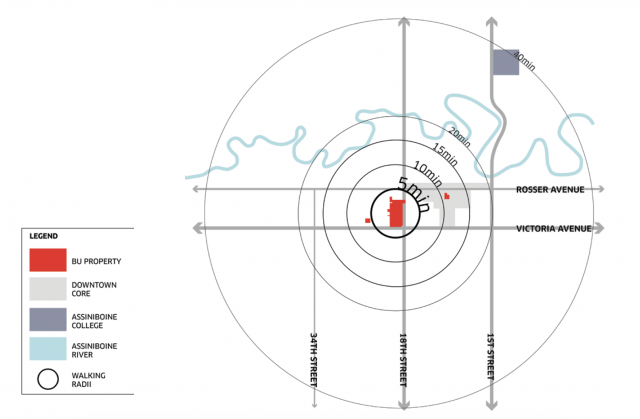
An Accessible and Connected Campus
BU, in a wider context, is an accessible and fairly well connected campus. The University is situated within a five to ten minute walking radius from the heart of downtown Brandon. It is twenty minutes from the Assiniboine River, valley and trails, and is within 40 minutes to the North Assiniboine College Campus. The Campus is connected to these key destinations, among others, via 18th Street, Rosser Avenue, and 1st Street.
Opportunities:
- Position the University as a key destination and amenity within Brandon
- Expand the trails system to connect an array of public spaces for recreation
- Provide additional services and amenities to meet the needs of the surrounding community and city
- Expand on educational and research offerings for greater partnerships and shared relationships with local elementary and post secondary institutions
- Implement the “missing link” identified in the City’s Active Transportation Plan that connects to Brandon University, which will better position the Campus as a key destination along the trail network.
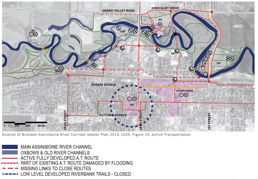
Excerpt of Brandon Assiniboine River Corridor Master Plan 2015-2035, Figure 15: Active Transportation
Local Scale
Relationship to the Surrounding Community
 BU’s main campus is located close to Brandon’s historic core, and a short walk from downtown. It is generally surrounded by residential development, with some commercial uses along adjacent major streets, such as Victoria Avenue and 18th Street. Two municipal parks, Coronation Park and Stanley Park, are a short walk from campus. The campus benefits from an excellent location in Brandon amidst an established and growing residential community. The University has easy access to local amenities and services, public transit services, and green spaces.
The relationship between the Campus and community can be mutually beneficial. Because of its location in the heart of a residential community, the University has the potential to provide additional services and amenities such as seniors housing on adjacent campus properties, student housing on campus, commercial and cultural uses, and a diversity of open spaces. All of these services and uses can increase the amenity base for the area and enhance relationships with the community.
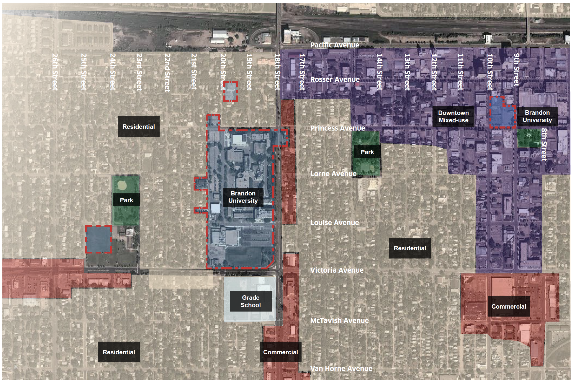
Local land use diagram, DIALOG
Relationship to Downtown Brandon
The University is within a ten to fifteen minute walking distance from the predominantly mixed-use downtown area, and specifically to Rosser Avenue which is the main commercial corridor. Opportunities to enhance the walking and cycling experience between the two city destinations can be a collaborative effort between the City and the University, and mutually beneficial to both.
The newly established land assembly for the University in the downtown core increases opportunities to service not only the surrounding community, but also the downtown community. Providing shuttle services to the downtown increases the accessibility to the campuses, and the increased use can be catalytic for downtown revitalization.
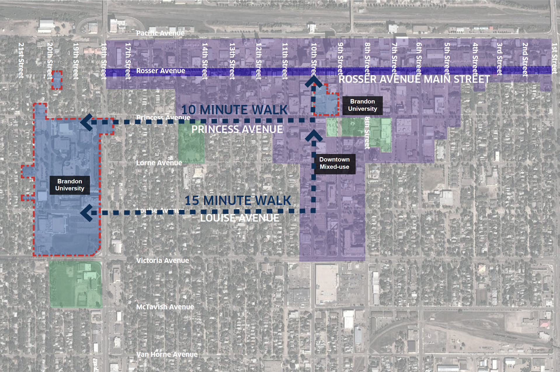
BU proximity to Brandon downtown diagram, DIALOG
Campus Scale
The following provides an analysis of the existing conditions and the opportunities within the Campus context.
Buildings and Campus Structure
 The evolution of the campus began in the early 1900s. The diagram reflects the build-out of the Campus to date. It was designed to be very intimate and pedestrian in character, with vehicular moment and parking at its edges, and predominantly pedestrian circulation in the core.
  Its buildings include a mix of academic, administrative, student residential, and maintenance facilities. In addition, the University owns three residential buildings at the intersection of Princess Avenue and 18th street, used as housing rental units.
Opportunities:
- Grow the University within it’s current boundaries, as there are many opportunities to expand on site with the development of the parking lot sites
- Incorporate existing heritage building assets in the Plan into the built form framework for future development
Campus Open Space
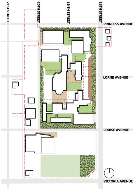 There are six different open space typologies identified on the Campus which include: a forested edge landscape, formal and informal courtyard spaces, an open field, small plaza spaces.
  Many of these spaces are remnant landscapes and open space alignments from the past campus structure.
Opportunities:
- Build on the many existing open space assets on the Campus and enhance structural components of the original framework that are still valid today
- Reinforce the north-south central spine through the Campus
- Bring the central open space adjacent to the library, and the formal Clark Hall open space to their original grandeur
- Create a new parking strategy for the campus so that existing lots can be used for new buildings and a diversity of open spaces
Circulation, Access, and Parking
The University is an integrated part of the surrounding neighbourhood street and block network for the most part. Generally, the grid pattern of development makes the campus accessible and connected to its surrounding context via neighbourhood streets and major roadways, but mainly from a vehicular perspective. It is defined along the east and south boundary by two major vehicular corridors of Victoria Avenue (Hwy 1A) and 18th Street (Hwy 10), which are main highway connectors through the city. These corridors are major barriers to the Campus from a pedestrian perspective. The traffic speeds, the width of the right-of-way, and the aesthetic of the streets, create an unsafe environment to pedestrians and cyclists alike and make crossing them a hindrance.
![]() There are five vehicular points of access into the Campus and at least 10 additional pedestrian points of access but there is no clear defined front door. Some of the neighbourhood streets such as Lorne Avenue have been dead-ended at the periphery of the campus. These streets can provide increased access and walkability to the Campus.
There are five vehicular points of access into the Campus and at least 10 additional pedestrian points of access but there is no clear defined front door. Some of the neighbourhood streets such as Lorne Avenue have been dead-ended at the periphery of the campus. These streets can provide increased access and walkability to the Campus.
The public realm is generally defined by surface parking lots. That said, most of the larger surface parking areas are situated at the periphery of the campus, at the west, or “back”, of the campus and south of Louise Avenue. ![]() Only smaller parking lot footprints are located within the Campus’ core. The extent of the west parking lots presents a negative interface to the adjacent residential neighbourhood. In terms of transit, the Campus is well serviced by the City’s transit system, with at least five stops at its periphery.
Only smaller parking lot footprints are located within the Campus’ core. The extent of the west parking lots presents a negative interface to the adjacent residential neighbourhood. In terms of transit, the Campus is well serviced by the City’s transit system, with at least five stops at its periphery.
Opportunities:
- Collaborate with the City and Province to create a strategy for the pedestrianization of the highways surrounding the Campus
- Open dead-end neighbourhood streets to connect to the Campus and make it more accessible
- Identify and define a hierarchy of gateways at key access points
- Enhance Campus’ streets as beautiful multi-modal but pedestrian prioritized movement corridors
- Enhance transit options with a new route through the Campus
Existing Building Frontages
Historically, the main address to the Campus has been its east face. The structure is such that the earlier buildings provided an easterly “face” or address to the street and adjacent neighbourhood. The development pattern shows that as the Campus evolved, buildings were inward facing, with frontages primarily to courtyard spaces and along Louise Avenue. 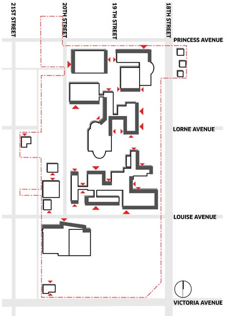 Frontages along Princess Avenue and 20th Street facing the neighbourhoods are fairly discontinuous. This is a typical pattern of development for institutions across Canada, where universities presented themselves on a podium to the community, and over time, gradually
 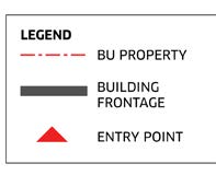 shifted to becoming more internally focused, turning their backs to the community.
Opportunities:
- Utilize the west parking lots as new development sites, to establish a building face to 20th street, and to repair the block by providing new buildings that respectfully transition to the adjacent residential buildings in height, scale, and massing
- Frame and define the sports field and create a frontage and identity along the highway corridors
- Use new developments to improve the face of the Campus, not only to the community, but also to the public realm within
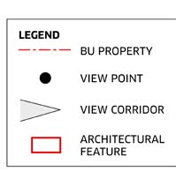
Existing Views and View Corridors
Identifying and enhancing views and view corridors are important to improving structure and wayfinding, building the Campus identity, and showcasing its assets.  The University already has, or the bones of, key view corridors that terminate at key buildings and architecture, that visually connect the Campus to the adjacent neighbourhood, and that emphasize key pedestrian corridors.
Opportunities:
- Maintain key sight lines and enhance views to the original buildings of Clark Hall and the Student’s Union Centre
- Enhance long views through the campus as opportunities for clear wayfinding
- Frame views to existing and new open spaces with new buildings
- Enhance view corridors into and through the Campus from the surrounding neighbourhoods